
2.10 Historical perspective on upper-air observations
Early meteorologists faced a challenge in taking weather measurements above Earth’s surface. Some weather stations were established on mountaintops, but the influence of the mountain itself meant that observations were not representative of conditions in the free atmosphere. Kites were an early means of investigating the upper atmosphere. In July 1749 in Glasgow, Scotland, Alexander Wilson attached several thermometers to six paper kites and flew them in tandem. He designed the apparatus so that the thermometers would fall to the ground unbroken at predetermined intervals. In this way, Wilson was the first to obtain a free-air temperature profile of the lower atmosphere (up to an altitude of about 60 m or 200 ft.).
On 27 August 1804, the French scientists J. L. Gay-Lussac (1778-1850) and Jean Biot (1774-1862) ushered in the age of manned balloon exploration. They took air samples, measured temperature and humidity, and on one ascent reached an altitude of 7000 m (23,000 ft.). On 5 September 1862, the British scientist James Glaisher (1822-1911) and his fellow aeronaut Henry Coxwell took weather instruments aloft in a balloon ascent over Wolverhampton, England. In less than an hour, they ascended to about 7600 m (25,000 ft.). They nearly perished from severe cold and oxygen deprivation in reaching an altitude of 9000 m (29,500 ft.) setting a new manned balloon altitude record.
Through the early part of the 20th century, weather instruments borne by kites, aircraft and balloons provided data chiefly on the lowest 5000 m (16,000 ft) of the atmosphere. On 4 August 1894 at Harvard’s Blue Hill Observatory near Boston, MA, kites were used for the first time to carry aloft a self-recording thermometer (thermograph). This instrument provided a vertical profile of air temperature to an altitude of 427 m (1400 ft.) above the ground. The next year at Mount Weather Observatory, VA, scientists used kites equipped with a recording instrument, called a meteorograph, to profile altitude variations in air pressure, temperature, humidity and wind speed. Wind direction was determined from the ground using a theodolite, an instrument that measures azimuth and elevation angles. On 3 October 1907, a box kite equipped with a meteorograph set a new world record in climbing to an altitude of 7044 m (23,111 ft.). On 5 May 1910, a train of 10 instrumented kites reached an altitude of 7265 m (23,835 ft.).
The success of kite experiments convinced the U.S. Weather Bureau in 1907 to begin operating a network of weather kite stations at several locations, mostly in the central part of the nation. Box kites, such as that shown in Figure 1, equipped with meteorographs profiled the atmosphere up to a maximum altitude of about 3000 m (10,000 ft.). The longest and last operating station, at Ellendale, ND, was closed in 1933. Among reasons cited for discontinuing the kite network was the relatively low maximum altitude reached by kites and the interruption in observations during episodes of light winds or calm air. For several years afterward, the U.S. Weather Bureau relied mostly on regular 5 a.m. (EST) aircraft observations originating at as many as 30 locations to probe the atmosphere to altitudes up to 4900 m (16,000 ft.), but this practice proved too hazardous and costly.
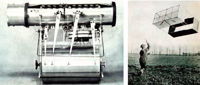
Figure 1: In the early 20th century, scientists probed the atmosphere up to altitudes of about 3000 m (10,000 ft.) using recording weather instruments (left) attached to box kites (right). [NOAA Photo Library]
A leap forward in monitoring higher altitudes came in the late 1920s with invention of the first radiosonde. A radiosonde is a small instrument package equipped with a radio transmitter that is carried aloft by a helium- (or hydrogen-) filled balloon. This device transmits altitude readings, called a sounding, of temperature, air pressure, and dewpoint (a measure of humidity) to a ground station. Radiosonde data are received immediately; no recovery of a recording instrument is required. The first official U.S. Weather Bureau radiosonde was launched at East Boston, MA, in 1937. By World War II, meteorologists were tracking radiosonde movements from ground stations using radio direction-finding antennas, thereby monitoring variations in wind direction and speed with altitude. A radiosonde used in this way is called a rawinsonde.